|
|
Trace Mayer Antiques 3700 Lexington Road Louisville, KY 40207 502.899.5335 |
|
| COMING SOON | |
Fine Art | |
| Drawings/ Watercolors | |
| Paintings | |
Furniture | |
| Chairs/ Seating | |
| Chests/ Case Pieces | |
| Chinese Furniture | |
| Clocks/ Barometers | |
| Desks/ Bookcases | |
| Miscellaneous | |
| Tables | |
| Mirrors | |
| NEW ARRIVALS |
| Assorted Objects | |||||
|
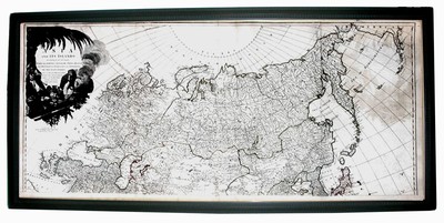
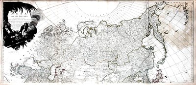
1787 Map of Asia and East Indies Description: 1787 MAP OF ASIA and EAST INDIES Northern section. Large ornamental cartouche at top left. In full, Asia And Its Islands according to D Anville; Divided into Empires, Kingdoms, States, Regions, andca. with The European Possessions and Settlements In The East Indies and An Exact Delineation Of All the Discoveries made in the Eastern Parts By The English under Captn. Cook ; London: Printed for Robert Sayer, Fleet Street as the Act directs, 6 Jany. 1787. Engraved map with color outlines. Printed on two sheets. Includes historical and geographical notes. Condition: is great overall, with slight browning to paper overall. Dimensions: Height- 21.25 Width- 48.25 Price: $875.00 Item ID: 22344 (use this number when calling our gallery) Print this item | ||||
| Home About Us Search |